Elm Street Green
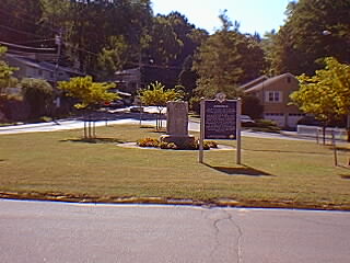
The Green across the street from the Ansonia Police Station marks the northern boundary of the Ansonia Historic District. In colonial times, the stocks for punishing wrongdoers and the posting board were located on this green, and it was the place where soldiers drilled and prepared for their service in the Revolutionary War. There is now a monument on the green in memory of the men who served in the First World War and an historic marker which was obtained by the Ansonia Historic District Commission from the Historical Commission of Connecticut in 1975 and erected on the site by the Ansonia Public Works Department. The plantings were donated and maintained by the Ansonia Garden Club. (Click pictures for larger images.)As you approach the Green, bear right on Rt. 243 and at the top of the hill bear to the left on Prindle Avenue. Go straight through the stop sign. This area was once known as 27 Squabble Hole, so named for two feuding families by the name of Weed, living there in the 1700's. It was the first settlement area in the Valley. The first four families settled here between 1654 and 1661. The very first plain meeting house of the First Congregational Church in Derby was erected here in 1682. Though none of these early structures remain today, a few ancient trees, old stone walls and foundation remnants still stand as silent sentinels to the earliest days of Derby. Go .3 miles - When you see Emmett O'Brien High School on your left, take a right on Ford Street. Go .6 miles and take a left on Benz Street. Go .5 miles and take a right on Milan Street and a quick left up Deerfield Road to the Ansonia Nature Center, the last settlement of the Paugasuck Indians. |
|
||
|
|||